For Hydrographic Offices
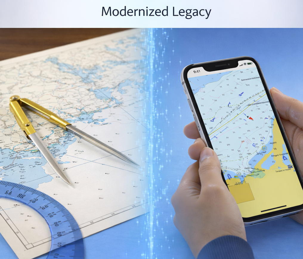
Extending Official ENC Coverage to Mobile Navigation Applications
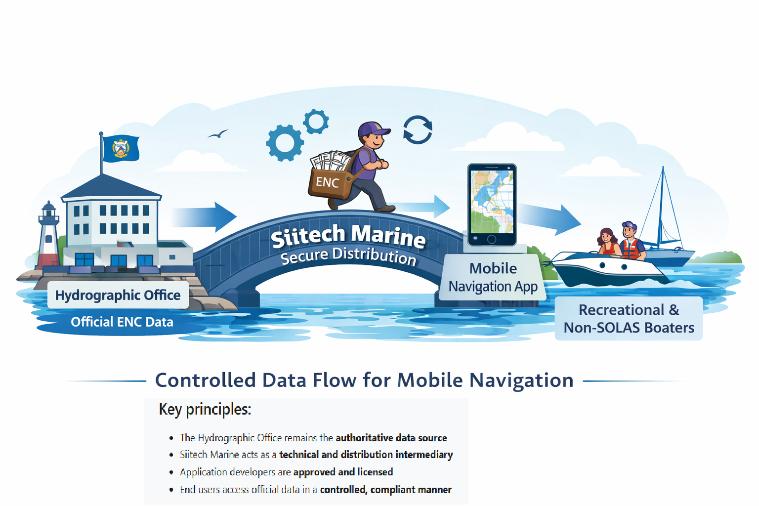
Siitech Marine works with national Hydrographic Offices to enable secure, controlled distribution of official ENC data to mobile navigation applications used by recreational and other non-SOLAS vessels.
Our role is to provide technical infrastructure and distribution services that allow hydrographic data to be made available on modern mobile platforms, while fully respecting Hydrographic Office authority, licensing conditions, and data integrity.
Alignment with IHO Principles
Siitech Marine operates in accordance with established hydrographic principles and practices, including:
- Distribution of S-57 ENC data issued by national Hydrographic Offices
- Support for IHO S-57 standards
- Chart presentation consistent with IHO S-52
- Secure data handling, access control, and update management
- Clear separation between ECDIS / SOLAS use and recreational / non-SOLAS use
For SOLAS-compliant ECDIS chart services, please refer to Siitech Marine’s ENC-derived vector chart distribution platform at https://siitechmarine.com
Siitech Marine does not position mobile applications as ECDIS systems and does not interfere with established ECDIS distribution channels, including those operated through IC-ENC, PRIMAR, or UKHO ADMIRALTY ECDIS services.
Supporting Safer Navigation in National Waters
Mobile devices have become a primary navigation tool for millions of recreational and small-craft users worldwide. In many regions, access to official, up-to-date nautical charts in mobile-friendly formats remains limited.
By enabling the distribution of ENC data through mobile navigation applications, Hydrographic Offices can:
- Improve situational awareness and safety for recreational boaters
- Reduce reliance on unofficial or outdated chart sources
- Promote the use of authoritative hydrographic data in national waters
- Support accident prevention, environmental protection, and safer navigation practices
This approach strengthens the visibility and relevance of hydrographic data in a rapidly evolving navigation environment.
Preserving Data Integrity and HO Control
Siitech Marine operates strictly within Hydrographic Office licensing frameworks. ENC data remains:
- Clearly identified as authoritative HO products
- Protected through secure distribution and access controls
- Updated using official update mechanisms
- Distributed only to approved and licensed application developers
Hydrographic Offices retain full control over:
- Data content and coverage
- Licensing terms and conditions
- Update policies
- Attribution and copyright
Siitech Marine does not modify hydrographic content and does not redistribute data outside agreed licensing arrangements.
Reaching the Mobile Boating Community Effectively
Traditional chart distribution models were not designed for high-volume, low-cost mobile use. Siitech Marine provides the technical platform that allows Hydrographic Offices to:
- Reach recreational and small-craft users efficiently
- Offer nationwide chart coverage in mobile-optimized formats
- Support frequent updates without additional operational burden
- Enable offline use while maintaining licensing compliance
This complements existing distribution models while preserving established standards and authority.
Benefits for Boaters
From a boater’s perspective, access to ENC data via mobile applications provides:
- Use of trusted, authoritative hydrographic information
- Improved understanding of local navigation conditions
- Reduced risk associated with unofficial or crowd-sourced charts
- Easier access to national chart coverage at an affordable cost
This encourages wider adoption of official data and supports safer navigation behavior.
A Complementary Role
Siitech Marine does not replace existing Hydrographic Office distribution partners or established models. Our role is complementary, addressing mobile navigation use cases that traditional distribution channels were not designed to serve.
Hydrographic Offices remain fully in control of policy decisions, data governance, and licensing strategy.
Scope of Use
The Siitech Marine mobile chart platform is intended for:
- Mobile navigation applications
- Recreational and other non-SOLAS vessels
SOLAS-regulated ECDIS distribution is handled separately through Siitech Marine’s dedicated ECDIS chart services at https://siitechmarine.com.
S-100 & S-101 Transition Overview
Executive Summary
The IHO S-100 framework represents the future foundation for digital hydrographic data services, introducing a modern and interoperable model for next-generation navigation products.
S-101, the new ENC Product Specification under S-100, will progressively complement and succeed the existing S-57 ENC standard as Hydrographic Offices introduce new datasets in line with IHO implementation timelines.
Siitech Marine fully supports official S-57 ENC services today and is actively preparing its platform and Chart SDK architecture to support S-101 and related S-100 products as they become available, ensuring continuity, compliance, and a smooth transition.
The IHO S-100 Framework
The IHO S-100 Standard is the Universal Hydrographic Data Model developed by the International Hydrographic Organization (IHO). It provides a modern, flexible geospatial framework designed to support a broad range of hydrographic and maritime information products.
The S-100 framework extends beyond traditional ENC data by enabling multiple types of marine and navigational information to be encoded, integrated, and exchanged within a unified and interoperable structure. It forms the foundation for the long-term evolution of digital navigation services and e-Navigation initiatives.
S-101: Next-Generation Electronic Navigational Charts
S-101 is the Electronic Navigational Chart (ENC) Product Specification developed under the S-100 framework. It represents the next generation of ENC data and will progressively complement and succeed the existing S-57 ENC standard.
S-101 retains the core navigational content familiar from S-57 while introducing enhanced data structures, improved portrayal capabilities, and greater interoperability with other S-100-based products.
Related S-100 Product Specifications
- S-102 — High-Resolution Bathymetric Surface
Provides detailed digital seabed depth models to enhance depth awareness, navigation safety, and advanced route planning. - S-104 — Water Level Information
Delivers dynamic water level and tidal height data to support under-keel clearance management and time-dependent navigation. - S-111 — Surface Currents
Provides real-time or forecast surface current information to improve navigation efficiency and safety. - S-124 — Navigational Warnings
Enables the digital distribution of official navigational warnings, including temporary and preliminary notices affecting navigation. - S-128 — Catalogue of Nautical Products
Defines standardized metadata structures for discovering, managing, and accessing hydrographic data products and services. - S-129 — Under Keel Clearance Management
Supports systems that calculate and manage safe under-keel clearance based on vessel characteristics and environmental conditions.
Implementation Timeline and Transition
The S-100 framework and its dependent product specifications, including S-101, are entering formal operational implementation beginning in 2026 in accordance with IHO standards.
During the transition period:
- Existing S-57 ENCs and new S-101 ENCs will coexist
- Hydrographic Offices will progressively introduce S-101 datasets
- Navigation systems and applications will adapt to support both formats
Initial S-101 production and pilot services have already commenced within selected national Hydrographic Offices.
Siitech Marine Readiness
Siitech Marine currently supports S-57 ENC services and is actively preparing its platform architecture and Chart SDK technology for future S-101 ENC integration in alignment with the IHO S-100 framework and Hydrographic Office implementation programs.
Support for S-101 will be introduced in line with official data availability, national hydrographic policies, and established licensing frameworks.
Siitech Marine’s approach ensures continuity of service while enabling a smooth transition toward next-generation hydrographic data standards.
Siitech Marine continues to follow the IHO S-100 development and implementation program closely to ensure long-term compatibility with evolving hydrographic data standards.
Engage With Us
Hydrographic Offices interested in discussing mobile ENC distribution, pilot projects, or policy-aligned implementation approaches are invited to contact Siitech Marine directly at info@siitechmarine.com.
All discussions are handled in accordance with national hydrographic policies and established licensing frameworks.